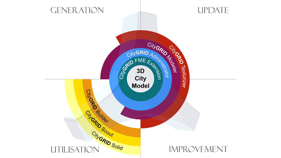
• 1 BG
  • 2 BG
  • 3 BG
  • 4 BG
  • 5 BG
  • 6 BG
  • 7 BG
 
Logo CityGRID Manager

CITYGRID®  MANAGER


Logo CityGRID Manager und CityGML

CityGRID® Manager is the central software module for managing 3D city models in a database system. The data storage is compatible to CityGML in the form of polygonal vector models. In addition, the building models are managed in an editable edge structure, which significantly facilitates revision and makes it possible to refine or update the city model using CAD and GIS data.

Pinion System requirements:

  • Oracle (no Spatial required)
  • Microsoft SQL Server (even the free Express Edition)

Tools Features:

  • Storage of building models as CityGML compatible surface models.
  • Management of the building structures in the editable CityGRID® edge structure.
  • Automatic consistency check.
  • Open object-relational database schema.


Schema CityGRID Module

 
  top of page 
 
 
Logo CityGRID Administrator

CITYGRID®  ADMINISTRATOR


Logo cg admin 220

The 3D city model database and the CityGRID® Manager functionalities are controlled by the client CityGRID® Administrator. This module covers the basic administrative tasks of the 3D city model, as well as databsse optimisation and cleanup.

ToolsFeatures:

  • Import / export of city and terrain models according to predefined areas or according to known building ID.
  • Export in the formats CityGRID, CityGML, KMZ, DXF and VRML.
  • Assignment of aerial images and orthophotos to the 3D city model.
  • Management of city models in the 3D database (versions, model properties, attributes, address linking, etc.).
  • Derive an elevation grid for visibility analyzes from the city model.
  • Automatic tiling of the terrain model according to the orthophoto tiling.
  • Control of the automatic intersection of overlapping building parts (automatic penetration resolution).


Admin 550

 
  top of page 
 
 
Logo CityGRID Texturizer

CITYGRID® TEXTURISER


Logo CityGRID Texturizer

Existing 3D city models can be automatically textured from oriented images using CityGRID® Texturiser. As a result, the attractiveness of the digital city model can be significantly improved with little effort. Oriented aerial photographs can be used for the texturing of roofs and facades, mobile mapping for the high-resolution texturing of street-side facades. CityGRID® Texturiser currently consists of a set of individual routines. A consistent user interface is under development.

ToolsFeatures:

  • Access to building models in CityGRID® or CityGML format
  • Import of aerial images and associated orientation parameters.
  • Automatic partitioning for better control of automatic processing.
  • Automatic texturing based on a surface clustering in order to guarantee a harmonious overall impression of the building texture.
  • Optional visibility analysis to minimise the mismapping of neighboring buildings.
  • Fast calculation through efficient storage management.
  • Parallelization of texturing process by utlisation of several work stations.
  • Optional packing of textures in atlases.


Under Construction

 
  top of page 
 
 
Logo cg FME 50

CITYGRID® FME INTERFACE


Logo CityGRID FME Schnittstelle

Many tasks of 3D city modeling can be solved more easily and efficiently in combination with the existing GIS. With the help of the CityGRID® FME interface, our software modules can be optimally linked to the customer's existing system environment. The CityGRID® FME interface expands the functional scope of FME by a reader / writer for CityGRID® data and enables the full import and export. Furthermore, some Transformers are added, which allow specific tasks of 3D city modeling. On the basis of the CityGRID® FME interface, customer-specific workspaces can be created for automising recurring 3D data processing tasks.

PinionSystem requirements:

  • FME Desktop Professional

ToolsFeatures:

  • Reader / Writer for the loss-free import / export of  CityGRID® data in all current GIS and CAD formats and CityGML.
  • 3D snapper with special 3D / 2D snapping behavior as well as recognition and securing of arc elements.
  • 3D Polygon Dissolver to optimally deal with roof surfaces.
  • 3D bufferer with ability to form partition lines between buffered polygons
  • 3D elevation interpolation from existing 3D surfaces


CityGRID FME Reader, Transformer und Writer

 
  top of page 
 
 
Logo cg modeler 50

CITYGRID® MODELER


Logo cg modeler 220

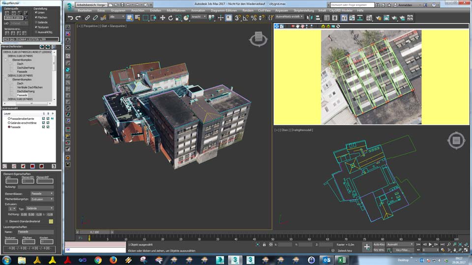
CityGRID® Modeler is the tool for 3D editing of building models. Thanks to its powerful editing and repair functions, modeling tasks, which are not automatically executable, can be done quickly in an interactive manner. With CityGRID® Modeler you can create 3D city models from roof lines and surfaces. Existing city models can be efficiently textured, refined and updated.

PinionSystem requirements:

  • 3D Studio Max (however, you do not need 3D Studio prior knowledge for working with CityGRID® Modeler).

ToolsFeatures:

  • Semantic editing of buildings, components, roof and facade details.
  • Graphical selection of the buildings to be edited or selection according to the building ID.
  • Optionally transparent representation of components for easier visual quality check.
  • Editing building attributes.
  • Efficient correction and modification of the building geometry.
  • Completion of LOD 3 building details (roof superstructures, roof terraces, etc.).
  • Creation of roof overhangs, individually for each facade or automatically according to existing footprints.
  • Simple modeling of throughways, superstructures and oriels, also with the help of existing surveying data.
  • Assembly of components or separation of buildings into different components.
  • Automatic resolution of penetrations between adjacent components.
  • Intelligent surface generation with automatic correction of the surface normals.
  • Automatic consistency control and quality assurance (eg with regard to water tightness).
  • Interactive texturing from photographic hand-held pictures.
  • Easily editing of the terrain model.
  • Export in the formats CityGRID®, CityGML, DXF and VRML.


ToolsOptional extension (in combination with CityGRID® Texturiser):

Semiautomatic facade texturing from mobile mapping recordings: After selecting a facade, CityGRID® Modeler proposes the texturing from the mobile mapping recording position, which provides the best viewing angle. However, it is possible that an obstacle, such as a truck, is depicted in this photograph. Therefore, the preview images are displayed from all other recording positions on which the selected facade is visible. If there are fewer or no visual obstacles in one of these shooting positions, this image can be used for the automatic texturing of the facade with a mouse click.

  • for the revision of the building models after the automatic facade texturing with CityGRID® Texturiser or
  • for the fast initial texturing of selected street-side facades.


CityGRID Modeler

 
  top of page 
 
 
Logo cg solid 50

CITYGRID® SOLID 


Logo CityGRID Solid

An important application for digital city models is the automatic generation of analogue models by 3D printing. These haptic models are still in demand in planning processes and are particularly used in architectural competitions. With CityGRID® Solid, a tool was developed that significantly simplifies generation of print files from city model data. By providing an area of interest, this CityGRID® module prepares the city model for 3D printing fully automatically.

ToolsFeatures:

  • Use of the logic of the city model in printing
  • Flexible selection of the area to be printed via a polygonal selection.
  • Setting the print scale.
  • Check for water tightness and correction for detected defects.
  • Output in the file formats 3MF, STL or OBJ.
  • Optional consideration of texture information.
  • Optional preparation of a terrain model stepped according to countour lines.
  • Automatic tiling in submodels according to the size of the printer.
  • Optional automatic excavation for the saving of printing material. (Depending on the printing method)


CityGRID Solid

 
  top of page   
 
Logo cg shaper50

CITYGRID® Shaper 


Watch here the video introduction of our new CityGRID® Shaper!

 Handbuch City<strong>GRID</strong><sup>®</sup> Experience a new, intuitive way of automated city modeling.


Logo CityGRID Shaper

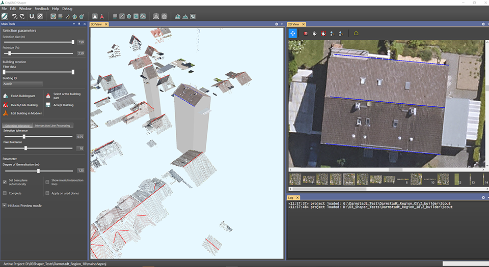
With CityGRID® Shaper, 3D building models can be created from point clouds - in a controlled and time-saving manner. With the help of aerial photos, the outer edges of the roof can be determined exactly, no building footprints have to be specified. The intelligent SmartPreview function gives you real-time suggestions about roof shapes that could match the data situation at the current mouse position. In this way, the real roof shape can be confirmed building part by building part with just a few clicks of the mouse and thus reconstructed exactly.

ToolsFeatures:

  • Data-driven roof modeling from 3D point clouds.
  • Optional: additional support through oriented aerial photos.
  • Automatic pre-calculation to determine candidates for roof planes.
  • Intuitive controlled modeling using the MagicPreview function.
  • Powerful editing functions to bridge any imperfections in the 3D point cloud.
  • Processing either in the 3D window of the point cloud or in the 2D window of the aerial photos.
  • 3D building modeling is also possible without given footprints.
  • If building footprints are available, roof overhangs can be generated.
  • Direct connection to CityGRID® Modeler for 3D modeling completion.


CityGRID Shaper

 
  top of page